Unified Climate Intelligence
Fuse meteorology, hydrology, terrain, and social signals into one adaptive platform that learns and improves with every event.


— Disaster Impact Observatory for Malaysia —
Resilient Communities, Safer Futures
NOACH’s mission is to safeguard communities, livelihoods, and critical infrastructure across Malaysia by transforming professional climate, water, terrain, and seismic observations into clear, decision-ready intelligence. We unify national meteorological, hydrological, satellite, and seismic feeds into a single operating picture that anticipates risk, not just reacts to it—delivering trustworthy early warnings and practical guidance that shorten response times and reduce losses.
At the core is the Disaster Impact Observatory (DIO): an interactive platform for nowcasting and live situational awareness tailored to Malaysia. DIO provides plain-language alerts and bilingual guidance, 48-hour outlooks, and map overlays for expected impact, arrival windows, and—during floods—estimated depth bands. Built on a Malaysia-first, privacy-preserving architecture that respects data custody, DIO equips households, SMEs, utilities, planners, and responders with the same truth so decisions are faster, clearer, and measurably more effective.
Early Disaster Warning System
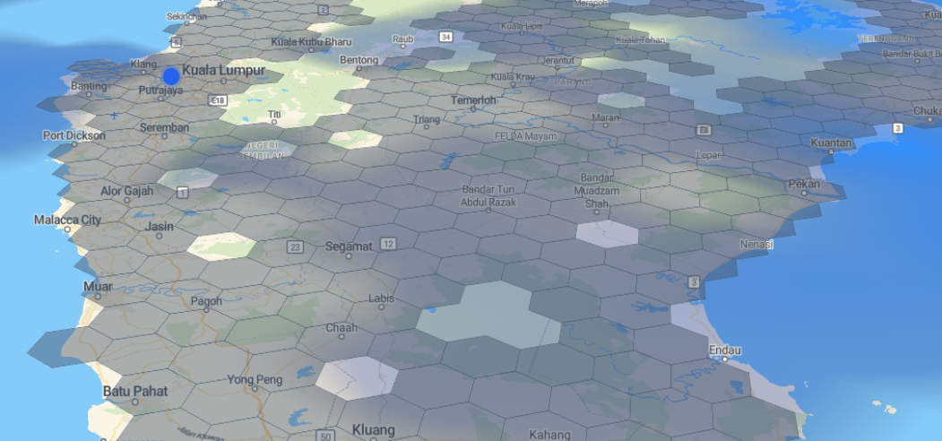
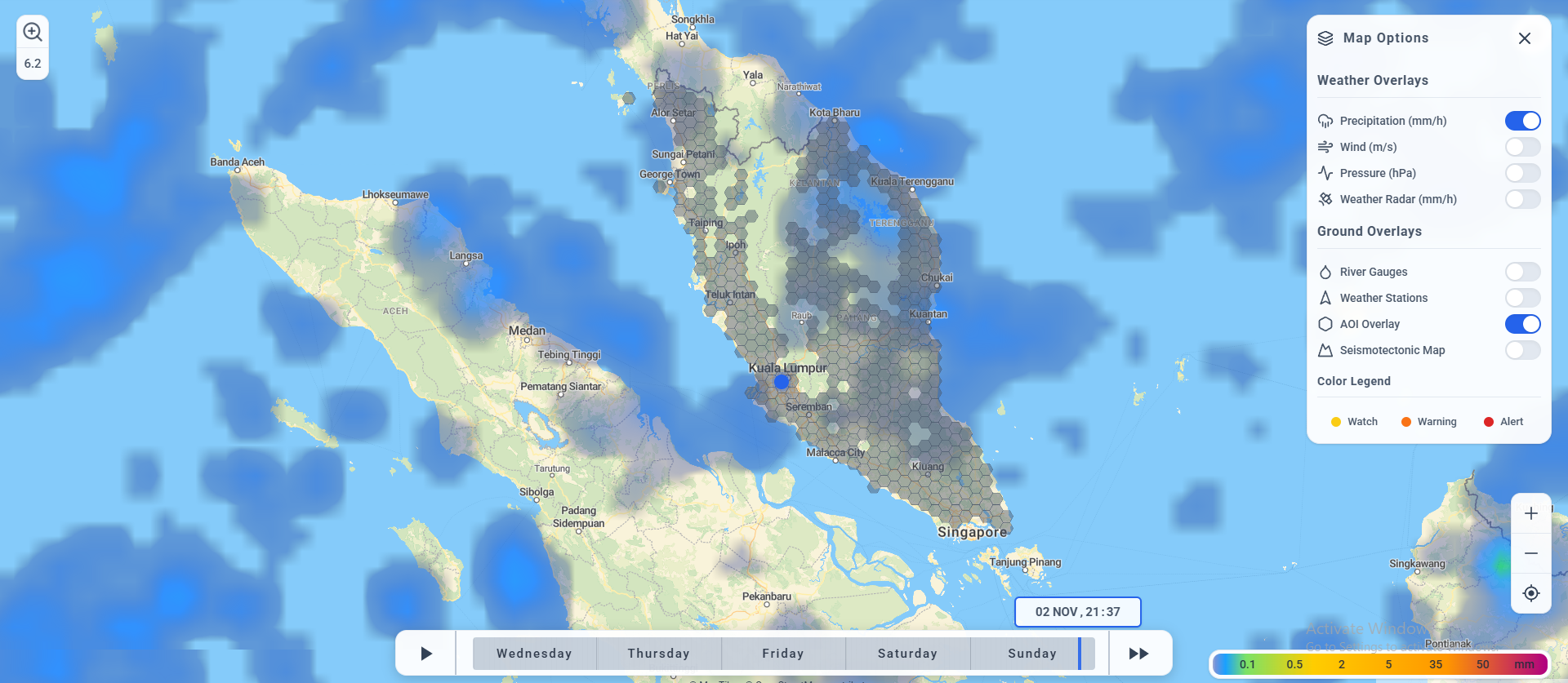
NOACH's Disaster Impact Observatory previews a basemap that extends beyond the capabilities of weather maps. Using NOACH's proprietary approach of integrating multi-point data sources, analyse, process and embed it into our DIO map. means we can not only observe weather forecast maps, but also relay the forecast data into our analytics to see how each area is reacting to the characteristics of the weather.
NOACH processes and analyzes 20 years of climate, hydrology, and terrain data, then maps it to 200km² & 5km² hex grid. Each hex cell holds its own local profile. Machine learning analyzes every cell to find thresholds, limits, and likely responses. Cells change color to show hazard severity.
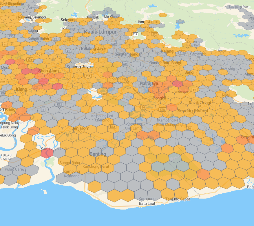

Centralising weather and monitoring data makes forecasts more accurate. Satellites and ground sensors cross-check, catch errors, and improve timing and impact. Outcome: clearer guidance, earlier warnings, fewer false alarms.
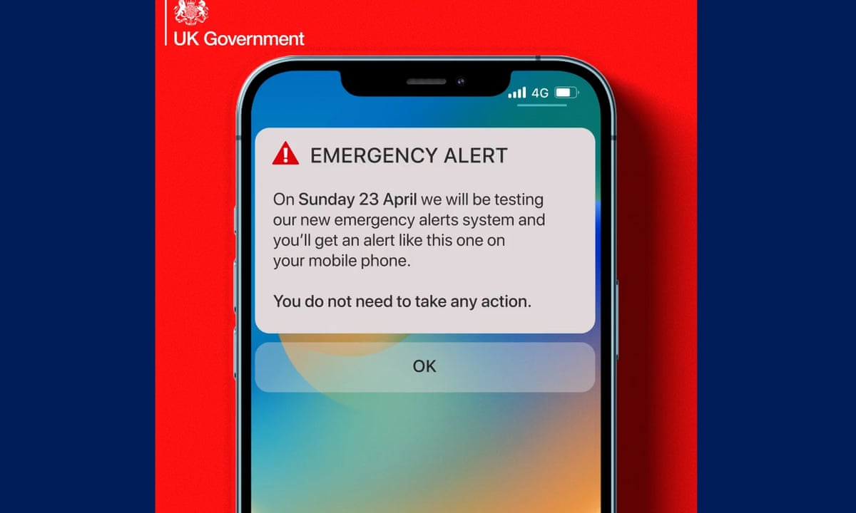
NOACH uses mobile and cell towers to position users. When a risk is detected, we issue staged notifications to users detected within the Area of Interest at T−12h, T−6h, T−3h, and T−1h with updated timing, likely impact, and clear actions. During an event, live updates continue until All Clear. Hazards covered include flood, flash flood, landslide, haze, coastal surge, and severe storm. Delivery on SMS, Socials and DIO-affliated outlet.
Every decision we make is backed by data, research, and proven climate science.
We design with people in mind — empowering both citizens and responders.
Preparedness today builds a safer tomorrow for Malaysia’s future generations.
Alerts adapt to where you are and your nearby risk zones.
T−12h, −6h, −3h, −1h notices sharpen timing and action.
Clear guidance before, during, and after severe events.
Fewer casualties and losses through earlier, clearer warnings and local actions.
Hit-rate target for event detection and impact guidance at neighbourhood scale.
Disaster warning system with forecasts up to 24 hours in advance.
A Malaysia that anticipates floods — not just reacts to them
NOACH’s vision is a nation where climate intelligence is woven into daily life: where every neighbourhood, city, and agency can see risk in real time, plan with clarity, and act early — turning data into safety, preparedness, and trust.
Fuse meteorology, hydrology, terrain, and social signals into one adaptive platform that learns and improves with every event.
Deliver timely, location-aware alerts and clear guidance to citizens, planners, utilities, and responders — on any device.
Turn insights into robust plans: flood-proof infrastructure, smarter zoning, and community drills that save lives and livelihoods.
⏱️ T-12h
Lead time goal for neighbourhood-level alerts
95%
Coverage of population centres by gauges & models
↘ 30%
Target reduction in response latency
24/7
Always-on monitoring & public dashboards
National data mesh: integrate rain radar, river levels, terrain, soil, drains, mobility and crowd-sourced signals.
Nowcasting + ML ensembles: short-range flood likelihood models refined by local ground truth.
Planning toolkits: risk zoning, design storms, and retrofit guidance for resilient districts.
Plain-language alerts: clear, bilingual guidance with actionable steps for households and SMEs.
“Resilience is built before the storm. Our vision is a Malaysia where every decision — from daily commutes to national planning — is climate-aware.”
NOACH is more than a platform — it’s a movement. We are expanding our datasets, strengthening partnerships, and building technologies that will safeguard Malaysia and Southeast Asia against the growing threat of climate-driven floods.